Opening Access to Our Rich Maritime Heritage
 Adam Kilgour
 Frankie Lau
How the 'Unpath’d Waters' project is providing a single point of reference for the study of maritime heritage.
This work is supported by the Arts and Humanities Research Council [grant number AH/W003384/1]

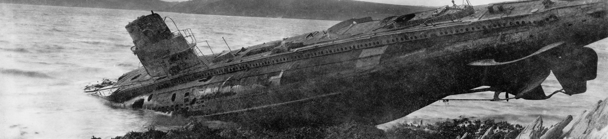
If you were looking for the story of U-Boat UC-70, an internet search would reveal that on 21 August 1918, the German submarine UC-70 left Zeebrugge on its tenth and final patrol of the First World War.
Several results pages later, the trail goes cold. Accessing maritime heritage is not always easy.
The tale of UC-70 can only currently be followed online by linking together stories from different websites.
The Unpath’d Waters project
The Unpath’d Waters project aims to bring the UK’s great maritime heritage together in one place to ease the process.
It is one of five major Discovery Projects funded by the Arts and Humanities Research Council (AHRC) as part of the 'Towards a National Collection' programme. The project is a national endeavour and brings together the four United Kingdom government heritage agencies, seven universities and 16 other partners and collaborators from the archaeological, museums, environmental data, charitable and commercial sectors.
Together, these organisations make up the Unpath’d Waters Consortium.
Unpath’d Waters is working to unleash the potential of the seafaring past for users all over the UK by drawing together information from a number of sources into a single accessible website resource.
Historic England is leading the £2.9 million project, which will explore how we can join up the UK’s amazingly rich and diverse marine and maritime heritage collections and use cutting-edge technology to unlock access to them.
Story Maps and ArcGIS development
This ambitious project will help increase accessibility to stories like that of UC-70 through Story Maps made with Geographic Information System (GIS) software.
You've got lots of information in museums, artefacts, and documentary sources. All of those things are fantastic, but if you can actually pull bits of those different types of data together and then present that story in Story maps, you can really bring it to life.
Story Maps lend themselves to following journeys through history by presenting information linked to time and place. They can include physical journeys from one location to another, or larger temporal journeys of artefacts.
UC-70’s patrol and other similar voyages are perfect case studies for the use of Story Maps. U-Boats kept very detailed logs of their movements and locations throughout different patrols, and this allows for a more in-depth and illustrative experience.
This benefit does not apply as easily to older ships as detailed logs were far less common in the Age of Sail. Specifically, the details of a journey may be limited to when the ship left and arrived in port and with some luck may include some bearings while at sea. However, even with this limitation, the use of the map and tracking can still provide a great visualisation of the types of journeys made by ships throughout history.
In addition, Story Maps will further increase the interactivity and ease of use for researchers by integrating maps with different multimedia to help create a more engaging, interesting, and valuable resource.
Frankie Lau, a GIS developer with Historic England’s Information Management and Technology department, is developing a prototype overlay in ArcGIS to help users access the maritime heritage which lies around our coasts. These provide a layer of heritage information laid onto a map or satellite view.
He began by collating all available information into a more digestible database for analysis. A conceptual diagram helped to visualise the complex relationship between the distinct factors, such as characters, remains, and activities, involved in an event at sea like the UC-70’s patrol and sinking.
It helped him visualise the protagonists, their nationalities, the action leading to an event, and what evidence remains of what took place. All this information paints a picture of the event and eases the process of transferring the data into map services using ArcGIS software.
Specifics of maritime voyages can often be hard to picture in relation to geographical boundaries. Through the map services, an interactive animation will be created to show how historic maritime events unfolded.
In the case of UC-70, this map will show its final journey from Zeebrugge to the coast of England and its eventual destruction. It will help to present this information in a new and engaging way.
The new system will also seek to improve the learning experience around Heritage Harbours. These are places of historic maritime significance which retain original features, buildings and facilities important for supporting historic vessels and maritime skills. Story maps will enhance this experience by allowing users to easily call up more information by clicking on different information points or through layers.
Sliders to compare historic and present-day maps will show the evolution of different ports and sea routes through time.
The end of UC-70’s story
On 28 August 1918, a Blackburn Kangaroo flown by Pilot Lieutenant Arthur Wearing of RAF 246 Squadron was on a routine anti-submarine patrol off the Yorkshire coast. A large oil slick covering the surface of the water was spotted and followed to its source, a long shadow underneath the waves. Wearing identified it as a probable submerged U-Boat and dropped a single bomb.
UC-70 was rocked by the explosion and began to leak more oil and air. HMS Ouse, a Royal Navy destroyer, arrived on the scene and began to drop depth charges on the U-boat until it finally succumbed to the punishment and sank.
The remains of the submarine, located off the coast of Whitby in North Yorkshire, were designated as a protected wreck site by Historic England in 2017.
The future
Currently, the project is focused on prototyping the database, the user interface, and the experience. The successful development of this stage will open new ways for the public to experience and learn about maritime heritage.
The Unpath’d Waters project is scheduled to run over three years, and the work completed on the GIS prototype will feed into it all. In addition, Historic England’s National Marine Heritage Record database (Mariner) will also incorporate the findings.
About the authors
- Name and role
-
- Name
-
Adam Kilgour
- Title and organisation
- Training and Content Support Officer at Historic England
- Details
-
- Description
- With a journalism background, Adam provides training and content creation for the IMT department of Historic England.

- Name and role
-
- Name
-
Frankie Lau
- Title and organisation
- GIS developer at Historic England
- Details
-
- Description
- Frankie is a GIS developer with 15 years' experience of GIS Web App development and map creation. His recent interests are building 3D GIS maps and using deep learning in geospatial analysis.


