Aerial Archaeology Mapping Explorer
Visit the Aerial Archaeology Mapping Explorer
 Damian Grady
 Simon Crutchley
Giving digital access to our aerial photography and archaeological mapping data.
Expanding digital access to our data is one of Historic England’s Strategic Activities, but it is only recently that new technology has enabled us to make such a large amount of data available online.
Historic England recently launched two web-based tools, which provide free access to over 400,000 aerial photographs from the Historic England Archive and 30 years of aerial archaeology mapping.
These new resources - the Aerial Photography Explorer and the Aerial Archaeology Mapping Explorer - give the public and heritage professionals alike unparalleled access to our aerial survey data, allowing them to discover and explore the changing face of England’s urban and rural landscapes over the last 100 years. They have proved to be a huge hit.

The Aerial Photograph Explorer (APEX) gives the public and heritage professionals access to over 400,000 aerial photographs.
The digital collection is made up of oblique photographs (taken from the side or front of the aircraft) and vertical photographs (taken from cameras looking straight down). Over 300,000 of the oblique photographs are images taken with digital cameras by the Historic England aerial reconnaissance team since 2005. The subjects primarily cover new archaeological discoveries and monitoring of known sites and landscapes.
Over 80,000 oblique photographs were taken by Aerofilms, a private aerial survey company set up just after the First World War. The Aerofilms collection provides a fascinating view of England before and after the Second World War. Scanning of thousands of the Aerofilms photographs was funded by the Heritage Lottery Fund (now the National Lottery Heritage Fund) as part of the Britain from Above project. Since then, more Aerofilms images have been scanned by the Historic England Archive and can be seen on APEX.
A further 900 oblique photographs available on APEX were taken by the Royal Air Force from reconnaissance Spitfires, with front-facing cameras in the wings where the guns would normally be situated.
The vertical layers consist mainly of 37,000 RAF photographs taken during and after the Second World War. These photographs, along with the RAF obliques, paint a vivid picture of the impact of war on England as the country adapted to defending itself with radar, anti-aircraft obstructions, and anti-aircraft batteries. They also chart the impact of enemy bombing on major cities and key military sites. The aerial surveys undertaken by the RAF in the late 1940s and 1950s made an important contribution to post-war planning as the country worked towards rebuilding and feeding itself. The remaining vertical photographs were taken by Historic England for cropmark prospection and detailed surveys of large archaeological landscapes to help colleagues carrying out research.
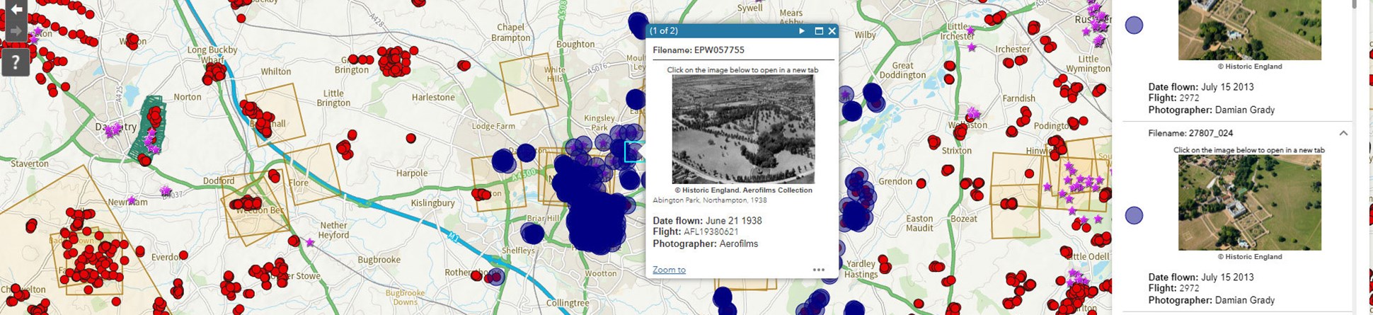
Users can search their area of interest using a gazetteer or the pan and zoom tools. There are two layers of data – oblique photographs and vertical photographs. Clicking on a dot marking the centre of an oblique photograph or the footprint of a vertical image allows the user to browse thumbnails. It is also possible to carry out queries based on dates of photography or user-defined areas. Individual images can be viewed in more detail at high resolution and there are tools for sharing photographs on social media or embedding them in websites.
The Aerial Archaeology Mapping Explorer provides free online access to more than 30 years’ worth of archaeological survey data produced by Historic England and its predecessor organisations. This includes projects carried out both ‘in-house’ and by grant-funded partners.
For the first time, it is possible to view the results of over 100 archaeological aerial mapping projects in one place.
The Aerial Archaeology Mapping Explorer is a tool that displays the archaeology that has been identified, mapped and recorded through the analysis of aerial photographs and airborne laser scanning data (lidar) across England.
This includes mapping all archaeological features seen as cropmarks, soilmarks, earthworks and structures with a chronological span from the Neolithic to the 20th century. The earliest projects, carried out over 30 years ago, were hand-drawn, resulting in varying degrees of accuracy depending on the landscape and available photography. By contrast, later projects were carried out in a fully digital environment. All aerial photographs were digitally rectified (a process to accurately remove all distortions in an image) using specialist software. Increasing use of digital methods improved the accuracy, detail, and usability of the mapping products.
The mapping relies on the photos held by the Historic England Archive and other collections, including the 400,000 digitised photos that can be viewed on the Aerial Photograph Explorer.
Since the 2000s, additional sources of capturing information have become available and the results have been incorporated into the mapping shown by the tool. National coverage of georeferenced orthophotography has been used for mapping projects through the Aerial Photography for Great Britain (APGB) initiative, used alongside online sources such as Google Earth. A relatively new source for mapping is airborne laser scanning data (lidar) which can enable the identification of subtle earthworks or features obscured by vegetation.
The mapping tool is designed to allow access to various levels of data, depending on scale. At the top level, there is basic information about the different mapping projects which have provided the data, including when they were carried out and in what format, as well as links to free archaeological reports. Below that, there is information about individual monuments as described in the Heritage Gateway (a website that offers local and national information relating to England’s heritage). Finally, the unique element of the tool provides detailed mapping of individual features, according to how they originally appeared in the landscape.
When using the mapping tool, selecting any identified archaeological feature provides a pop-up box, which shows basic information about the type, period and form of the feature and the source that it was seen on, as well as a link to the more detailed record or project report. At the most detailed level there are links to detailed descriptions of the ‘period’, ‘type’ and ‘evidence’ terms, to help those unfamiliar with some of the terminology.
Visit the Aerial Archaeology Mapping Explorer
The two Explorer tools have shown how the aerial viewpoint can be used to engage people with all aspects of the historic environment.
The launch days for both tools saw the highest ever number of visits to the Historic England website, stimulating significant increases in views of other content such as list entries and Research Reports. Press coverage for the Aerial Photograph Explorer alone had an estimated audience reach of over 250 million people.
Since launch these resources have received hundreds of thousands of visits and continue to be visited over 7,000 times a day at time of writing.
Both tools will continue to develop over the coming months and years. New photography taken by the Historic England aerial reconnaissance team will be added to the Aerial Photograph Explorer. Furthermore, the Historic England Archive plans to gradually add more of their 6 million historic prints as they are digitised.
As for the mapping of archaeology, Historic England and our partners will continue to carry out aerial mapping projects and the results of these will be uploaded to the Aerial Archaeology Mapping Explorer as they are completed. We also hope to improve the usability of early hand-drawn mapping data by providing links to records hosted on Heritage Gateway. Enhancements to functionality are also being explored, particularly making the data available in a format that others will be able not just to view and query, but also to incorporate into their own applications.
The authors would like to thank the many people who made this possible - the Historic England Archive and others who supplied the crucial aerial sources to allow our work to happen, all the aerial archaeologists who took the photos and/or created the mapping and interpretations, and all those who supported our work programme, from the Historic England Grants team to the many partners we have worked with over the years.


Explore England's changing landscapes through historic aerial photography, showcasing the growth and transformations of urban and rural areas.
Explore archaeology identified and mapped by aerial archaeology using our map
Historic England experts use airborne remote sensing methods to identify, record and monitor the condition of heritage assets
Our website works best with the latest version of the browsers below, unfortunately your browser is not supported. Using an old browser means that some parts of our website might not work correctly.


