Farmstead Characterisation Methods
The following techniques have been developed to inform fresh research and future planning:
- 'Farmsteads Mapping', a technique for enhancing Historic Environment Records which uses Ordnance Survey maps of around 1900 as a baseline to record their historic character and survival
- Using this data for 'Mapping Current Use'
- Rapid assessment, sometimes using the results of mapping, which result in national, regional and local 'Farmstead Character Statements' which use available sources and knowledge to set out their historic character, significance and issues for change
This work has helped to inform our revised advice on traditional farmsteads and buildings, and more detailed research and survey techniques.
Farmstead character statements
These use available knowledge and observation, including Farmstead Mapping where available, to describe:
- How farmsteads contribute to local character and distinctiveness, and any special significance in a local or national context
- The drivers for change and the issues to consider when considering change
- Area variations
Standard terms - included in a national Farmsteads Thesaurus and National Character Statements - have been used to define the different types of traditional farmstead layouts or types, and their buildings.
Farmsteads mapping
This technique for digitising farmsteads in Geographic Information Systems (GIS) uses the second edition Ordnance Survey maps compiled around 1900 as a baseline, because these were surveyed after the last major phase of constructing traditional farm buildings in England. Each of the records include the following key attributes:
- The historic form or layout, noting the position of the farmhouse
- Recorded date of the farmhouse and working buildings from the local Historic Environment Record, almost all of these being for listed buildings
- Survival of their historic form, which enables their potential for conservation, enhancement and further investigation to be identified
Analysis of these attributes against datasets and other published evidence on landscape character has demonstrated a close relationship between the historic character and survival of farmsteads, and how the historic character of the landscapes around them has developed.
The method is summarised with a case study from the Hampshire pilot in Extending the Evidence Base. A manual, first produced for the West Midlands Project and used for all projects, has been updated with guidance for users of Historic Environment Records.
Mapping current use and context
'Extending the Evidence Base' summarised analysis of the present-day use of surviving mapped farmsteads in Hampshire, Sussex and the High Weald AONB. The work was led by Peter Bibby of the Department of Town and Regional Planning at the University of Sheffield (TRP), and who then extended this technique for over 17,000 farmsteads in the West Midlands.
For more information see:
Key findings
Below are some of the key issues which our characterisation of the historic character, survival and use of traditional farmsteads has raised, and which are set more fully in Adapting Traditional Farm Buildings: Best Practice Guidelines for Adaptive Reuse.
Local differences
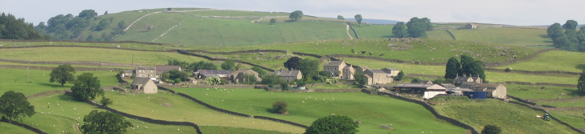
Traditional farmsteads and their buildings make a significant contribution to local character and distinctiveness, including varied patterns of settlement.
Different levels of significance
- Over 70% of traditional farmsteads in existence at the beginning of the 20th century have retained some or all of their historic form, and thus have the greatest potential to contribute to local character and distinctiveness. The rates of survival are highest in upland areas and lowest in villages and some coastal marshlands and arable vales
- Only a small minority - often under 20% - of these have listed buildings, and most of these are houses rather than working buildings
- The dates of farmstead buildings reflect different wave of rebuilding and economic activity across England, pre-1700 buildings being exceptionally rare.
Different types of use
- Most traditional farmsteads are no longer in farming use, sometimes as low as one third but much higher in upland areas where farming families lack the income or incentive for maintenance
- Data for listed and unlisted buildings has consistently revealed the difficulty of finding a commercial use (around 10% of the total) for surviving traditional farmsteads, whether designated or not
- New uses, including for on-farm diversification and home-based working, are contributing to new forms of rural economic activity and communities
- Regardless of their location, historic farmsteads in residential use (which may involve the conversion of buildings) are more often used for home-based entrepreneurial businesses than any other kind of urban or rural property.
Further reading
Farmsteads mapping methods
For the principles of the approach see:
Lake, J and Edwards, B 2006. ‘New approaches to historic farmsteads’, 'Landscape Character Network News', Issue 22
Lake, J and Edwards, B 2006. ‘Farmsteads and landscape: towards an integrated view’, 'Landscapes', 7.1, 1–36
Lake, J and Edwards, B 2007. ‘Buildings and place: farmsteads and the mapping of change’, 'Vernacular Architecture', 37, 33–49.
For more detail on the technique used for mapping, including for rapid creation of Historic Environment Records and their integration into HBSMRs, see:
Edwards, B, Lake, J and Hansom J 2009, revised 2016. 'Historic farmsteads. A manual for mapping'. Historic England, Forum Heritage Services and Locus Consultants
Farmstead mapping project reports
The first of the project reports below was the pilot conducted for Hampshire which raised issues summarised in Lake and Edwards 2006 and 2007 above. For more on Shropshire, Herefordshire, Warwickshire, Worcestershire and the West Midlands Conurbation see the West Midlands Farmsteads and Landscapes Project. This was led by English Heritage, now Historic England, in partnership with the region’s county and metropolitan councils, and has for the first time at a regional level identified the historic character and present-day role of farmsteads across a whole region.
Baxter, C and Lake, J 2010 Shropshire Historic Farmsteads Characterisation Project. Report for the West Midlands Farmsteads and Landscapes project
Edwards, B 2005. Historic Farmsteads and Landscape Character in Hampshire. Pilot Project. Forum Heritage Services. Pilot project report for English Heritage (now Historic England)
Edwards, B 2006. Historic Farmsteads and Landscape Character in West Sussex. Forum Heritage Services. Forum Heritage Services. Unpublished report for the High Weald Joint Advisory Committee, West Sussex County Council and English Heritage (now Historic England)
Edwards, B and Lake J 2007. Historic Farmsteads and Landscape Character in Hampshire. Forum Heritage Services. Final county report for English Heritage (now Historic England)
Edwards, B 2008a. Historic Farmsteads and Landscape Character in The High Weald AONB. Forum Heritage Services. Unpublished report for the High Weald Joint Advisory Committee and English Heritage (now Historic England)
Edwards, B 2008b. Historic Farmsteads and Landscape Character in East Sussex. Forum Heritage Services. Unpublished report for the High Weald Joint Advisory Committee, English Heritage (now Historic England) and East Sussex County Council
Edwards, B and Lake, J 2010. Farmsteads in the West Midlands Conurbation. Forum Heritage Services. Report for the West Midlands Farmsteads and Landscapes project.
Edwards, B and Lake, J 2010, rev. 2012 Historic Farmsteads and Landscape Character in Staffordshire. Forum Heritage Services. Report for English Heritage (now Historic England) and Staffordshire County Council
Edwards, B, Lake, J and Banister, N 2012. Farmsteads and Landscapes in Kent: A Report on the Mapping of Traditional Farmstead Character and Survival. Forum Heritage Services. Report for English Heritage (now Historic England)
Edwards, B, Lake, J and Banister, N 2014. Farmsteads and Landscapes in Wiltshire: A Report on the Mapping of Traditional Farmstead Character and Survival. Forum Heritage Services. Report for English Heritage (now Historic England)
Edwards, B and Lake, J 2014 North Pennines Farmsteads and Landscapes Project. Forum Heritage Services. Report for English Heritage (now Historic England) and North Pennines AONB.
Edwards, B and Lake, J 2015 Historic Farmsteads and Landscapes Character in the Peak District. Forum Heritage Services. Report for English Heritage (now Historic England) and Peak District National Park
Hathaway, E and Lake, J 2010. Worcestershire Historic Farmstead Characterisation Project. Report for the West Midlands Farmsteads and Landscapes project
Macintosh, A and Partington A 2015 (forthcoming). Farmsteads and Landscapes in Lincolnshire. Report for Historic England
Morton, B and Lake, J 2010. Warwickshire Historic Farmstead Characterisation Project. Report for the West Midlands Farmsteads and Landscapes project
Rimmington, N and Lake, J 2010. Herefordshire Historic Farmstead Characterisation Project. Report for the West Midlands Farmsteads and Landscapes project. Herefordshire Council Archaeological Service
In this section
-
What Is Rural Heritage?
England's rural landscape includes a great range of heritage assets from historic buildings to archaeological remains.
-
Farm Buildings and Traditional Farmsteads
Our advice and approach for ensuring the historic character, survival and use of traditional and historic farm buildings.
-
Support and Funding for Rural Heritage
Rural heritage can benefit from programmes that offer advice and funding for the care of heritage in rural settings.
-
Metal Detecting
A summary of the conditions regarding metal detecting on agri-environment land.
-
Creating New Woodland
Find the information and advice you need to create new woodland whilst also protecting the historic environment.
-
Protected Rural Landscapes
How we work with National Parks and the National Association of Areas of Outstanding Natural Beauty.
-
Landscapes & Areas
The historic environment is managed not only at the level of individual buildings, sites or monuments, but also in terms of entire landscapes.


